
The Age is running a story about Google Maps at the moment and the apparent “ferry disaster” in Sydney Cove:
The ferry “collision” appears right beside a giant cruise liner – either the Queen Elizabeth 2 or Queen Mary 2 – which was docked at Sydney Cove when the photographs were taken.
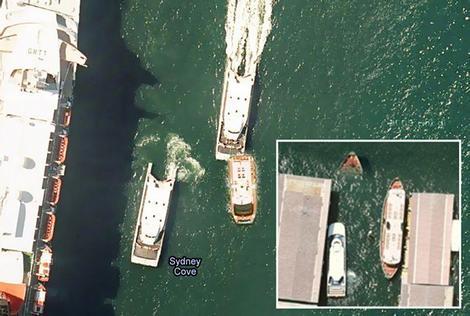
The image appears to show a ferry travelling at full speed colliding with a smaller boat. Metres away, another boat appears submerged under water except for the tip of its nose. Source: theage.com.au
Google have said that this is just an image stitching issue. The interesting thing is that the Age couldn’t be bothered to research their story properly. Two things indicate that the Liner in question is in fact the Queen Elizabeth 2: the fact that she is berthed facing out into the harbour, whereas the Queen Victoria was facing Circular Quay; and secondly, a quick Google revealed that the call-sign on the roof of the Bridge “GBTT” belongs to the QE2.
Link to Google Map [^], with the QE2’s call sign clearly visible.